Alan Silverstein,
ajs@frii.com
Last update: Sep 25, 2012 (minor Feb-Apr 2026)
(Proposal was submitted to the USGS: January 28, 2004)
Contents:
(April 2026: Ancient history now, many of the links are dead, but I'm keeping this webpage around for historical interest and possibly other unforeseen uses.)
This webpage constitutes a proposal to the United States Geological Survey (USGS) Board on Geographic Names (BGN) for the official naming of a collection of geographic features, all located in Glen Canyon National Recreation Area (GCNRA) in southeast Utah, administered by the National Park Service and the Bureau of Reclamation. The names and this proposal are...
Contents of this section:
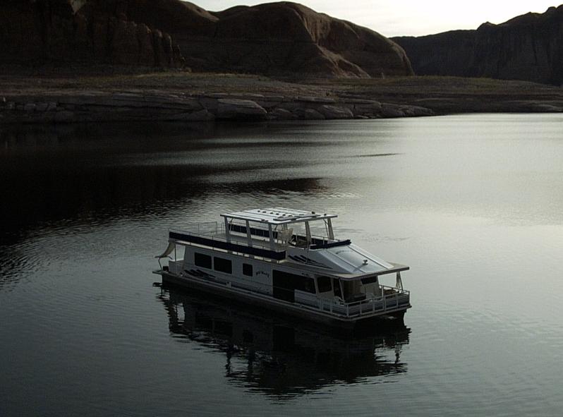
Since 1990 I've been a shareowner of a large private houseboat based at Bullfrog Marina on Lake Powell in GCNRA. (Previously the Wildwind I, replaced in 2001 by the Wildwind II.) I'm an explorer and avid hiker who has spent nearly 200 nights in GCNRA... See also my webpage on neat hikes at Lake Powell, and my tutorial called Houseboating 101.
For our amusement and convenience over the years my crews and I have given informal names to dozens of unnamed features such as smaller canyons. Recently it occurred to me, it would be appropriate and fun to propose some -- but not by any means all -- of "our" names for formal adoption. (If it were 30 years ago and I were Stan Jones, I would just carve the name on the wall, such as, "Carrot Top Arch, August 1973", and then publish my own maps... Grin.)
I have some idea how the naming process works because in the early 1990's I helped the Planetary Society name Mars Hill in Death Valley, California. Furthermore, in the summer of 2003 I assisted some NASA astronauts in supporting a family dedication campout and hike, and placing a memorial plaque on the newly-named Columbia Point, Colorado; whereby I became acquainted with a staffer at the USGS Board on Geographic Names who has offered me advice regarding the present proposal.
Doing some research, I found on the web: Principles, Policies, and Procedures: Domestic Geographic Names.
Within which there is this section: Proposing Names for Unnamed Domestic Features.
I believe that my placenames would agree with the following excerpts:
...the Board realizes that there are occasional needs for reference or commemorative purposes to name features that are presently unnamed.
I think the names proposed here would help provide points of reference in large areas with otherwise few recognized named features; plus increase human appreciation of the newly named natural features.
...it must be acceptable to local citizens, involved local, State, and Federal agencies, and other users.
For GCNRA I believe the relevant parties are:
This is a remote area largely uninhabited except by visitors, with the exception of a few proposed names that are adjacent to (Piute Bay, Cha Bay) or on (Not Cha Canyon) or the Navajo Reservation side of the lake.
(*) In prior communications with the GCNRA Public Information Officer I was told the NPS has no categoric objections to naming proposals within Glen Canyon, and that some previous proposals had been approved; although of course their support would depend on the details of the proposal.
...The Board's responsibility is to evaluate each name proposal as to appropriateness, acceptability, and need (relative to the feature, its location, and the user community)...
I believe most of these names would be acceptable on this basis.
...These guidelines apply only to features that have never been named.
True in all cases as far as I can determine.
...Names for features already established in spoken or written form among local citizens, even though the names do not appear on current maps, are given priority...
There are few or no local citizens, depending on how you define "local". I might be as close as it comes since I've spent nearly 200 nights on the lake! (grin)
For a "Proposed New Name" which is non-commemorative, the following information is requested in "Appendix C. Domestic Geographic Name Report".
| Copy Submitted By: Alan Silverstein | Title: (none) | Telephone (day): 970-226-0477 | Date: January 28, 2004 |
| Company or Agency: (none) | Address: 4012 Sunstone Drive, Fort Collins, CO 80525 | ||
(Form -- May 1995)
|
|
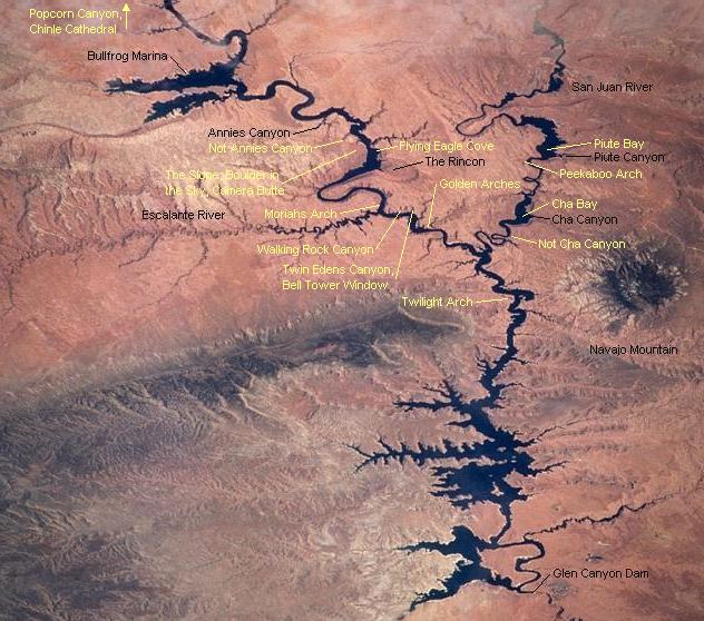
This picture of Lake Powell taken from orbit, looking northeast, has been annotated to show the approximate locations of all features with proposed names (yellow), plus a few other well-known reference points (black). |
Note: Lake level is 3700' at full pool. The elevation is shown as "(lake)" below for water features and for canyons whose mouths are normally submerged.
Results: In their May 12, 2005 meeting, the Board approved 7 of my 17 proposed names, as indicated below and confirmed by this letter I received by email June 16.
| App? | Recommended Name | Map | Coordinates (NAD 27) | Reference | Source | Elevation (feet) | 7.5-Minute Quadrangle | Utah County | ||
|---|---|---|---|---|---|---|---|---|---|---|
| Feature Class = valley (north to south): | ||||||||||
| 1 | yes | Popcorn Canyon | map | 37°40'44"N | 110°28'34"W | mouth | map | (lake) | Good Hope Bay 1987 | San Juan |
| 2 | no | Not Annies Canyon | map | 37°21'09"N | 110°45'17"W | mouth | map | (lake) | The Rincon 1987 | Kane |
| 3 | no | Walking Rock Canyon | map | 37°16'21"N | 110°51'29"W | mouth | map | 3750 | The Rincon 1987 | San Juan |
| 4 | no | Twin Edens Canyon | map | 37°15'46"N | 110°51'25"W | mouth | map | (lake) | The Rincon 1987 | San Juan |
| 5 | no | Not Cha Canyon | map | 37°10'05"N | 110°51'16"W | mouth | map | (lake) | Wilson Creek 1987 | San Juan |
| Feature Class = bay (north to south): | ||||||||||
| 6 | yes | Flying Eagle Cove | map | 37°19'16"N | 110°46'06"W | mouth | map | (lake) | The Rincon 1987 | San Juan |
| 7 | yes | Piute Bay | map | 37°10'60"N | 110°41'59"W | center | map | (lake) | Deep Canyon North 1987 | San Juan |
| 8 | yes | Cha Bay | map | 37°09'57"N | 110°49'03"W | center | map | (lake) | Wilson Creek 1987 | San Juan |
| Feature Class = arch (north to south): | ||||||||||
| 9 | no | Moriahs Arch | map | 37°17'33"N | 110°51'51"W | point | GPS | ~3657 | The Rincon 1987 | Kane |
| 10 | yes | Bell Tower Window | map | 37°15'55"N | 110°51'02"W | point | map | ~4200 | The Rincon 1987 | San Juan |
| 11 | no | Golden Arches | map | 37°14'44"N | 110°52'07"W | point | map | ~4000 | Wilson Creek 1987 | San Juan |
| 12 | no | Peekaboo Arches | map | 37°11'31"N | 110°43'48"W | point | map | ~4440 | Deep Canyon North 1987 | San Juan |
| 13 | yes | Twilight Arch | map | 37°08'23"N | 110°57'37"W | point | map | ~3662 | Nasja Mesa 1987 | Kane |
| Feature Class = slope: | ||||||||||
| 14 | yes | The Slope | map | 37°20'27"N | 110°46'47"W | center | map | 3480-5100 | The Rincon 1987 | Kane |
| Feature Class = summit (north to south): | ||||||||||
| 15 | no | Boulder in the Sky | map | 37°20'44"N | 110°47'27"W | point | GPS | ~5200 | The Rincon 1987 | Kane |
| 16 | no | Camera Butte | map | 37°20'23"N | 110°47'43"W | point | map | 5102 | The Rincon 1987 | Kane |
| Feature Class = area: | ||||||||||
| 17 | no | Chinle Cathedral | map | 37°40'59"N | 110°27'09"W | center | map | ~3740 | Good Hope Bay 1987 | San Juan |
Comments: You can comment on this proposal by writing to the Board on Geographic Names.
Regarding Vreeland numbers referenced below, the webmaster of the Natural Arch and Bridge Society (NABS) website explained to me:
The numbers are from a series of self-published books by Robert H. Vreeland called "Nature's Bridges and Arches." Unfortunately all 20 or so of these volumes are out of print. But they remain probably the best single arch catalog in existence. The first number refers to the volume, and the second number is the sequence within the volume.
Regarding stereo pair images below... To view these images: Select one pair of images to expand the thumbnail to "full size" -- still not large because people can't uncross their eyes very far. Look between the pair of pictures and relax your eyes (uncrossing, looking "through the screen" into the distance) until the two images split and a "middle" (third), stereo image fuses and appears in the middle. If necessary -- if your eyes can't "uncross" far enough to fuse the third image -- make the images smaller somehow (might be hard) or back away from the screen.
Some people can do this easily and some can't, sorry. One way to tell is to look at a distant object like a mark on a wall while holding up one finger closer to your eyes and nearly in line with the mark. If while continuing to focus on the distant dot you can "see" two images of the finger (and it doesn't cause you a headache), your brain does not "filter out" one image or the other and you are a good candidate for naked-eye viewing of stereo pairs. Some people just can't see two images, which means they probably can't uncross their eyes and fuse two stereo images either. Also, if you are old like me and have bifocals or reading glasses, you might need to tip your head or use them so the focus is good.
Note: There are at least three other ways to share stereo images, but they are all less portable:
Where available, images are presented here as thumbnails. Select any image to enlarge it; file sizes range from 29 to 111 Kb.
Note:
| 1. Popcorn Canyon | (map) | (up to summary) |
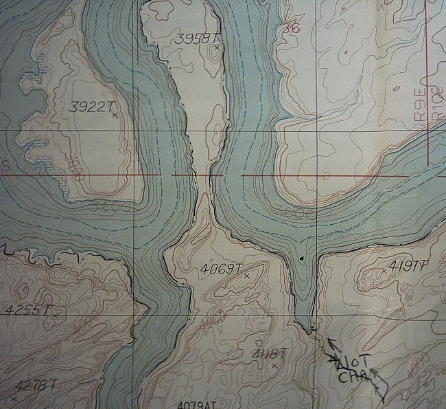
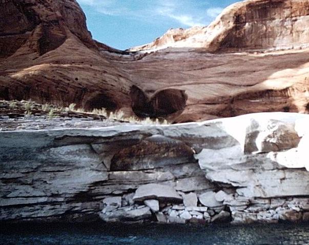
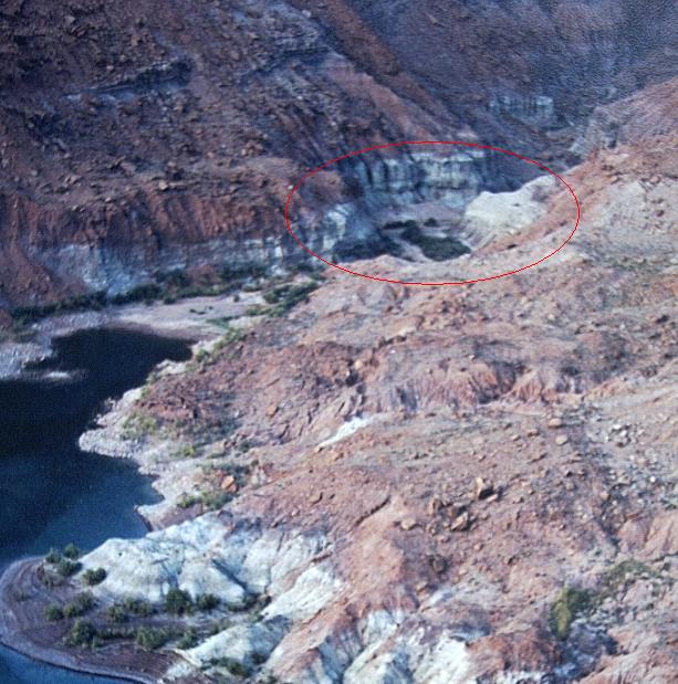
This canyon trends nearly due east and slightly south for about one mile from its mouth on the east side of central Good Hope Bay. At the east end it forks symmetrically. A short hike up the left (northeast) fork from full pool is the "Chinle Cathedral".
The proposed canyon name is in reference to odd and unusual white-centered calcite concretions weathering out of red Chinle mudstone. These are found at "Popcorn Beach" (a colloquial name not being formally proposed), 37°40'32"N, 110°27'31"W, a bit south of the center of the fork at the east end of the canyon, at and below the full pool line.
Note: Popcorn rocks are unusual but not rare in GCNRA. However, they are usually found in white or pink Navajo sandstone. I've never seen another place offering red popcorn from Chinle mudstone.
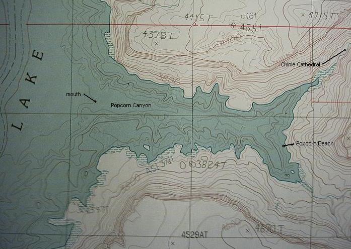
Annoted photo of a USGS map showing Popcorn Canyon and Chinle Cathedral. |
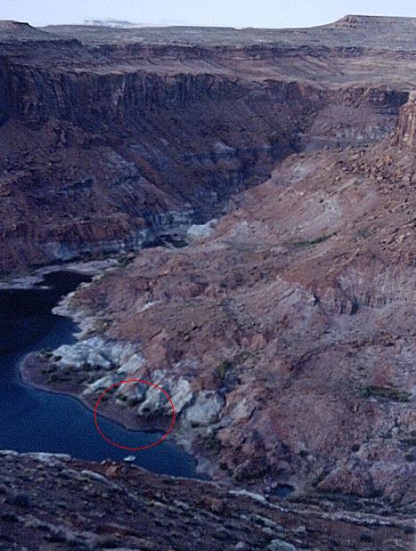
Looking down north-northeast from a 4670' high point to the fork at the east end of Popcorn Canyon. "Popcorn Beach" is approximately in the red ellipse. |
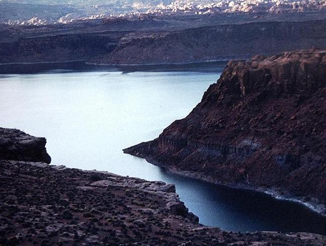
View down northwest to the mouth of Popcorn Canyon, across Good Hope Bay to Ticaboo Creek. |
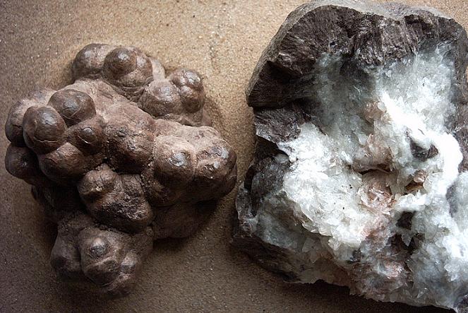
Exterior and interior views of some "popcorn rocks". |
| 2. Not Annies Canyon | (map) | (up to summary) |
This short canyon is the next major gulch downstream on the same side (river-right, north) as Annies Canyon. It trends northwest and west for about half a mile from its mouth. Like Annies Canyon, it cuts deeply into the Waterpocket Fold. Unlike Annies Canyon, it's possible to hike up and out the back of this unnamed gulch to access high terrain north of "The Slope". More than once I've witnessed people look at this attractive valley and confuse it with Annies Canyon, but it's... "Not Annies".
I realize that this proposed name, along with "Not Cha", might seem odd or frivolous at first, but after years of use by my crews it has become a natural, meaningful, and useful name, as well as humorous.
The view east-southeast out Not Annies Canyon from the rear of a houseboat early on a morning with a bit of rain. |
| 3. Walking Rock Canyon | (map) | (up to summary) |
This box canyon trends north-northeast in Navajo sandstone from its mouth just downstream of the Escalante River on the opposite site of the Colorado River (east side, river-left). By GCNRA standards it is an unremarkable and seldom-visited finger whose mouth is above and set back from the lake, even at full pool.
In 1992 I explored for the first time as far as possible up and out of this canyon. Unlike the next (unnamed) parallel canyon downstream, I've never found any Anasazi ruins here, and unlike the subsequent (unnamed) canyon downstream ("Twin Edens Canyon"), the end of "Walking Rock Canyon" is relatively simple. But high on a shelf above a glen, just north and west of the end of the canyon, I found a most amazing and rare "Walking Rock". Naturally we began to refer to this canyon by the proposed name.
In September, 1993 and again in October, 1998 I revisited the Walking Rock and took friends to see it. Another friend got directions from me and experienced the rock for himself in July, 2000. Unfortunately when I returned for the fourth time in November, 2003 I discovered that the rock had collapsed its legs, presumably of natural causes (it appeared there might have been a large rockfall nearby recently), and they had mostly washed away.
However, the Walking Rock was far beyond any similar feature I've ever seen elsewhere in GCNRA. The proposed name for the canyon still seems fitting as a tribute to the odd sculpture it once housed.
Hiking into Walking Rock Canyon, view southeast. Note the unusual rounded-dome pillar of Navajo sandstone that marks the downstream side of the mouth of this canyon. |
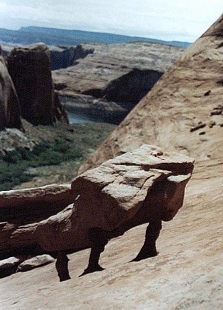
The Walking Rock when I discovered it, May 28, 1992, looking west-southwest down and out the canyon, including the pillar at the mouth. |

Another picture taken the first day. |

With a person, for scale, October 6, 1998. |
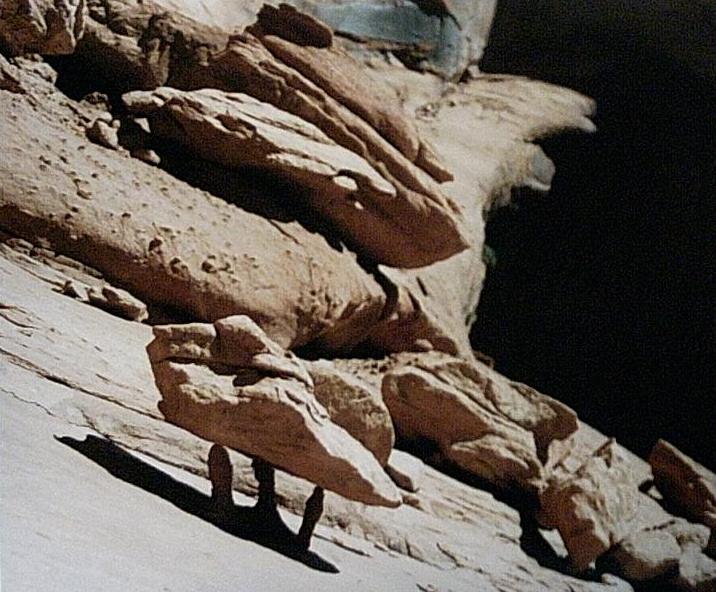
Looking up-canyon the same day. |
| 4. Twin Edens Canyon | (map) | (up to summary) |
For many years we passed by this relatively short valley without finding time to explore it. It trends about half a mile east curving to northeast, "two doors down" from "Walking Rock Canyon". When we finally did moor at the back, scramble up through Kayenta sandstone cliffs, and walk further toward the end on a shelf below the Navajo sandstone, we found a treasure trove of unusual and scenic features... The "Bell Tower Window", a "picnic rock" on a promontory at the fork, overlooking a remarkably deep and narrow gully, with twin waterfalls murmuring down the slickrock into a pool in the depths, and a pair of gorgeous gardens at both ends shortly upstream from the fork.
I've taken to referring to these sheltered desert alcoves as "Edens"; hence the proposed name of this canyon. Also note the similar but different use of the term in the name of Lost Eden Canyon, an area of barren slickrock just downstream from Halls Creek Bay.
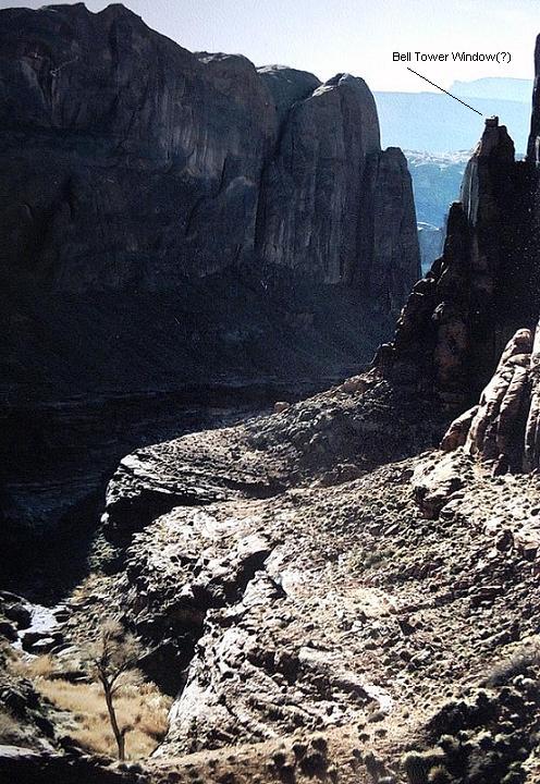
Southwest down and out from high in Twin Edens Canyon, including the probable location of the "Bell Tower Window". (No, discovered later that it's higher and further downstream.) |
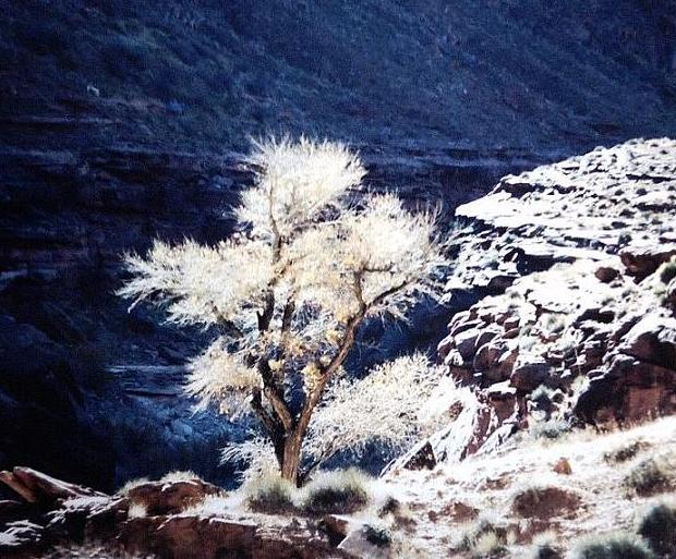
A backlit, leafless (in late November) cottonwood tree near the end of the canyon. |
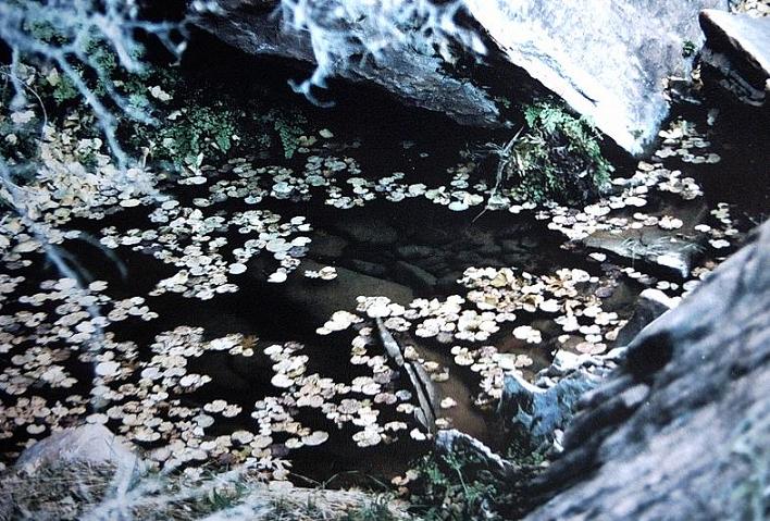
Water in the desert! A closeup view of a small pool in the lush "garden" at the end of the right fork. |
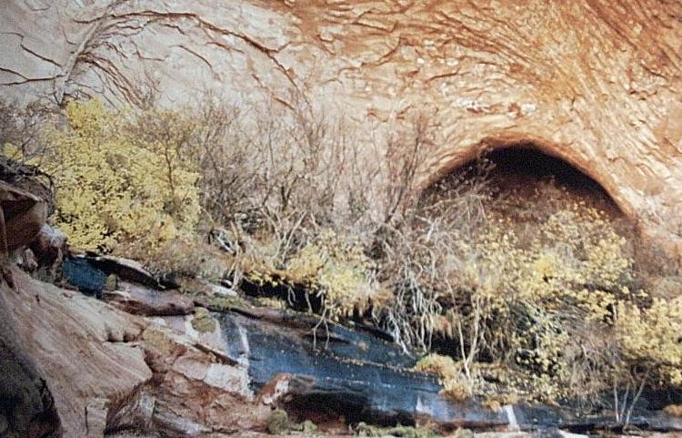
It's hard to capture the scope, beauty, feeling, and even the smell of an "Eden" like this one. Here you see the sculpted sandstone, a bit of vegetation, and the natural trickle of spring water above the larger garden at the end of the right fork. |
| 5. Not Cha Canyon | (map) | (up to summary) |
Once upon a time in my early days exploring GCNRA, before I had a good map, I allowed a somewhat disoriented friend to lead me and some others on a hike up this short (perhaps quarter-mile of lake), south-going canyon on a hunt for the well-known Anasazi petroglyphs of Cha Canyon. We had a good hike up and out to the base of some high cliffs, but of course we didn't see the petroglyphs.
Nowadays as we travel beyond the third gooseneck up the San Juan River toward "Cha Bay", when people ask, "are we there yet?" we point to this canyon and say, "No, sorry, that's... Not Cha." We tell them to be patient as we must loop around one more gooseneck to reach the bay.
I don't seem to have any photos of this canyon! In lieu of that, here's a map showing its location, marked with the hike we took "by accident" in my early days on the lake. The north/south canyon to the west is Nasja / Bald Rock. |
By the way, further upstream on the northern tip of the promontory into this gooseneck there stands a remarkable orange sandstone pillar about 200' tall, the remnant of a relatively recent rockfall. Some people on other boats call it the "Peatness Rock" -- not really, but I want to keep this G-rated -- and we've always called it "Clock Rock" -- again, not really, but you get the idea. I have some fine pictures and I'd love to propose a formal name for this feature, but will demur for obvious reasons (grin).
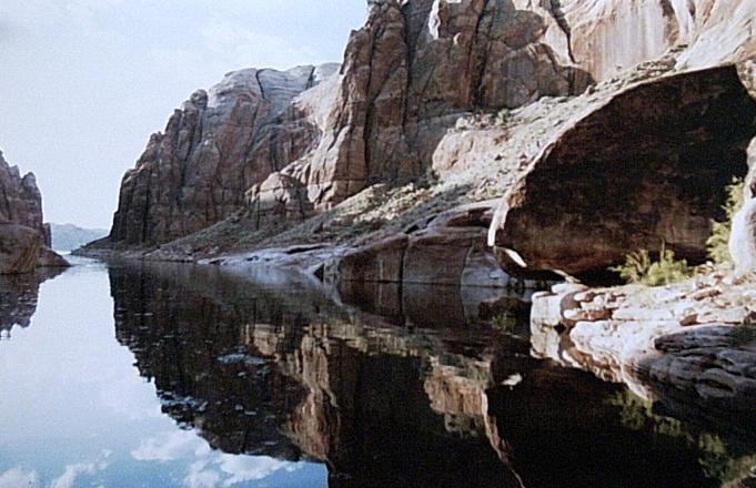
| 6. Flying Eagle Cove | (map) | (up to summary) |
This small bay and short, steep canyon trends south-southeast from its mouth on the east (river-left) side of the Colorado River between Iceberg Canyon and the upstream arm of the Rincon. I've actually seen the proposed name on one commercial map sold at the lake, but I've lost the reference.
The proposed name refers to the wonderful arch "hidden in plain sight" high above the Cove to the southwest. This massive, sweeping arch was formerly known colloquially as "The Kissing Elephants" and also as the "Flying Eagle Arch" until recently when it was renamed Aleson Arch.
I have nothing against the new name, but the old one was even prettier and more memorable. I think it would be fitting to name the Flying Eagle Cove in rememberance of the previous name of the arch. It would also be useful for navigation and enhance the experience of visitors to the area.
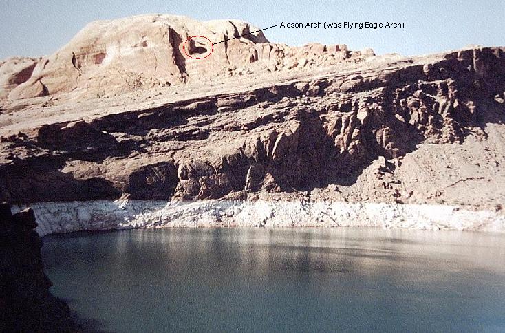
View southwest across the Cove to the Arch from a small remainder of the Waterpocket Fold (The Slope) on the south side of the lake just west of the mouth of Iceberg Canyon. |

Flying Eagle Cove is the closest part of the lake in this view to the northeast through Aleson Arch. Some of the Henry Mountains are visible in the distance. |
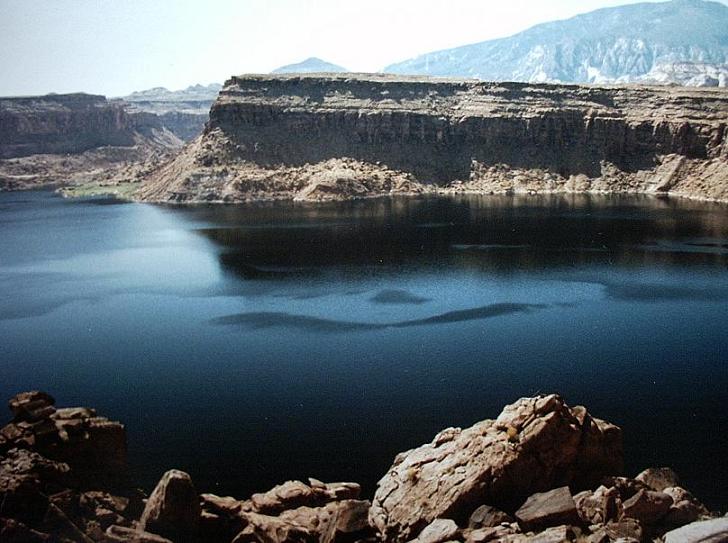
| 7. Piute Bay | (map) | (up to summary) |
The two largest bays on the San Juan River arm of Lake Powell are not formally named. Curiously, further upstream the much smaller Zahn Bay does bear a commemorative name. Since Piute Canyon runs north into the largest bay, naturally we frequently refer to it as "Piute Bay". I simply propose to formalize this name for clarity.
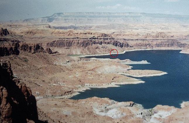
West across the downstream side of Piute Bay from ~ 5200' on Piute Mesa south of Neskahi Wash. In the red circle the barely visible white dot is a houseboat 3.1 miles away moored near the mouth of Piute Canyon. |
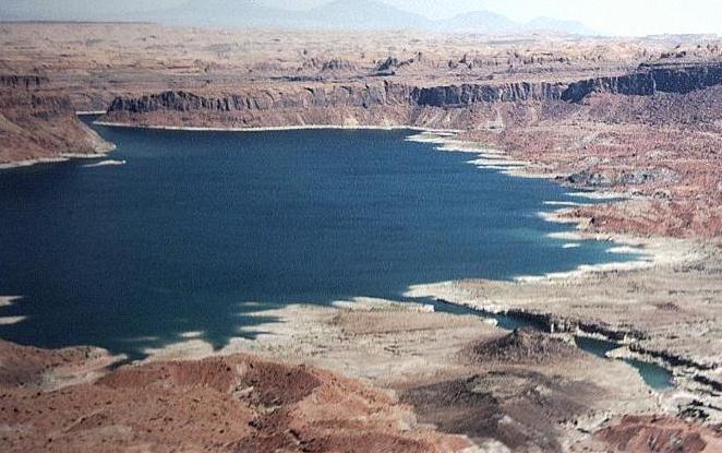
North across the upstream side of Piute Bay from around 5200' on Piute Mesa south of Neskahi Wash. |
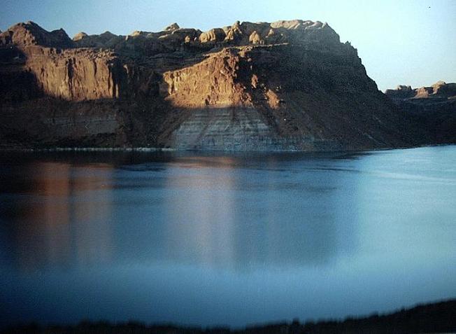
North-northeast across Piute Bay from a high ridge east of the mouth of Piute Canyon. |
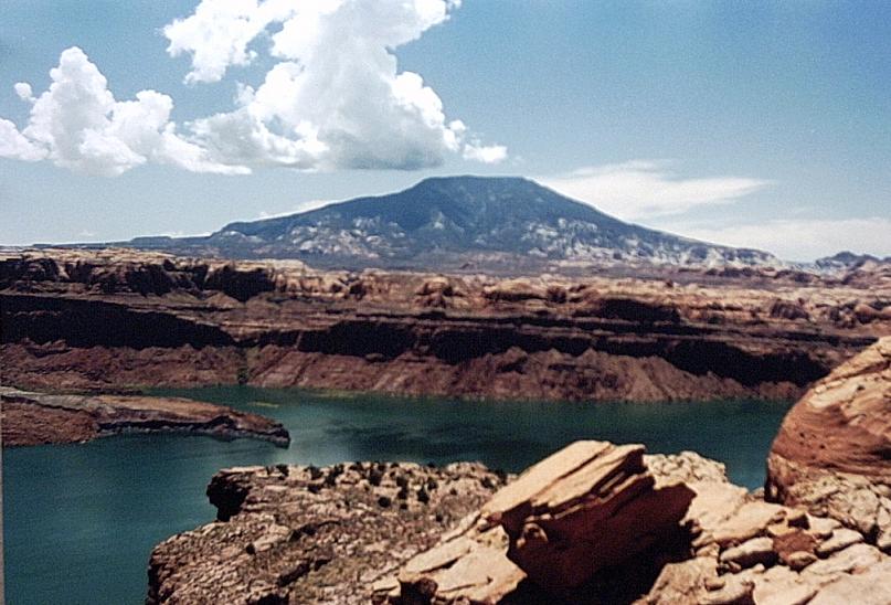
Southwest across Piute Bay to Navajo Mountain from the top of the cliffs; the mouth of Piute Canyon is on the left in the distance. |
| 8. Cha Bay | (map) | (up to summary) |
As with "Piute Bay", since Cha Canyon runs north into a large, unnamed bay which we frequently refer to as "Cha Bay", I simply propose to formalize this name for clarity.
Looking south across Cha Bay to Cha Canyon and Navajo Mountain, from the high cliffs of Kayenta and Wingate sandstone on the north side. |

View southwest across Cha Bay to Cha Canyon and Navajo Mountain, from the high cliffs of Kayenta and Wingate sandstone on the north side. |
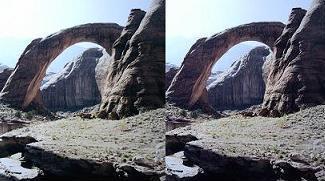
| 9. Moriahs Arch | (map) | (up to summary) |
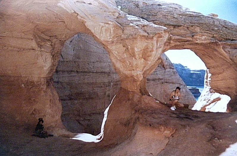
An impressive "landscape arch" (Vreeland 7-21a) is hidden at the top of Kayenta sandstone cliffs about half a mile upstream (east, on river-right) of the mouth of the Escalante River on the north side of the main channel of the Colorado River. I discovered and walked across this arch sometime in 1989-93 before it subsequently went back underwater as a drought ended and Lake Powell rose. It re-emerged in 2002 and is presently high in the air above the lake.
It's possible to walk a short distance up a slope from downstream to visit the arch, or to climb "up and out" through its left-side crack. At the top there's a narrow slot parallel to the lake. The crown is wide and massive enough for many people to stand on it together.
This classic arch deserves a name even though sometimes it's sometimes 40' deep. (Please note that I'm not also asking to name the enormous arch whose roof is at elevation 3590' in Rock Creek Bay, that I discovered by snorkeling last summer... Grin.)
Why "Moriahs Arch"? Because, "They Call The Wind Moriah..." A few years ago, playing tourguide for my crew and wanting to offer them a "photo opportunity" as we passed by this arch, I had a "learning experience" which resulted in me writing the following advice:
Never drive the houseboat toward shore with a strong tailwind while one or more little boats are on tow. Just about the time you cancel your drift and think you have it all under control, you'll see a little boat floating downwind alongside the helm and hear its owner screaming epithets. This situation constitutes an "unusual attitude" from which recovery is difficult.
The arch is in a wide, open area on the main channel of the Colorado River where the wind can really howl. We made the connection on the next trip later that year when a friend's daughter with the unusual name "Moriah" was the first person we know of to climb up through the back crack. Life is full of such odd synchronicities...
Nice evening light on Moriahs Arch along with what we call the "Heart Cave" behind it. 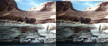
Same image as a stereo pair. |
Up and north from a boat to Moriahs Arch with people climbing up to the Arch. |
A person (coincidentally, Moriah) on top of the Arch, from a houseboat moored directly below. |
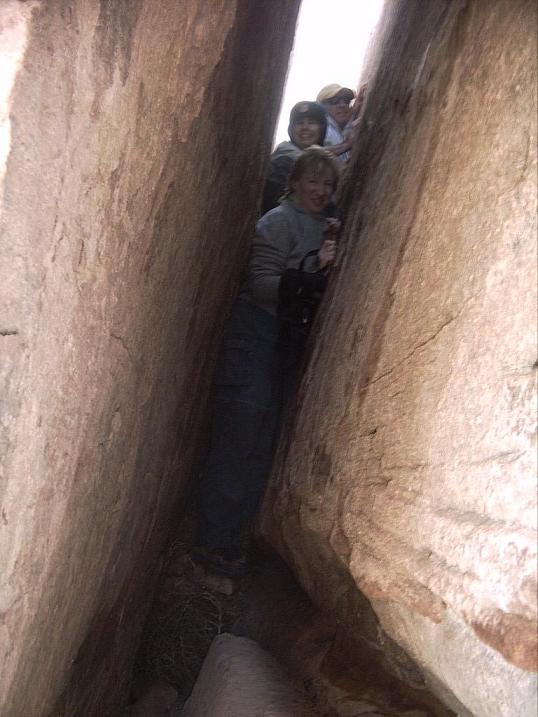
People crammed into the narrow left side crack, the direct route to the top of the arch. |
Houseboat Wildwind looking southeast from just below Moriahs Arch -- on a calm day (grin). |

A unique view of a houseboat, through the back slot of the Arch. |
Note: Later it came to my attention that there are two variations on the spelling of "the wind": "Mariah" and "Moriah". Here's the story...
My friend's daughter is named Moriah, the Biblical spelling, so that's what we thought was correct. Later when I hunted on the web for "call the wind moriah" I found plenty of instances of it spelled that way, and assumed it was correct. But in preparing this proposal I was not able to locate the source of the song, and it never occurred to me to try the "A" spelling. Guess what, there are plenty of web-hits with "Mariah" too, including indications that it was a Kingston Trio song in 1959 with the "A" spelling, long before the movie "Paint Your Wagon" appeared in 1969. So perhaps the "correct" name should be, "Mariahs Arch"?
Also on the web I found this...
Mariah... not to be confused with Mount Moriah, where the temple in Jerusalem is built.
The song first appeared in the musical "Paint Your Wagon" by Alan Jay Lerner and Frederick Loewe, and was later a big hit by the Kingston Trio
Also, in many cases the song list for the "Paint Your Wagon" album says "Maria" with no "H"!
Note: I found no "Mariah" in any GNIS feature name in Utah either.
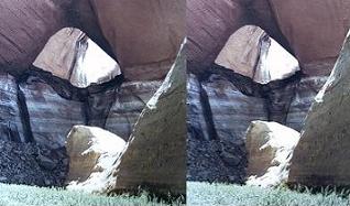
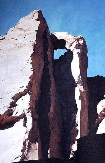
| 10. Bell Tower Window | (map) | (up to summary) |
This magnificent and unexpected opening (with no Vreeland number) resides high above the lake in the top of a huge stone pillar on the north side of Twin Edens Canyon. It cannot be seen from the lake, only by hiking up the canyon well above the full pool line. Our discovery of this unheralded arch was one of those blessed surprises hidden "just around the corner" in GCNRA. As soon as we noticed it one of my crew christened it with the proposed name, which I still think is perfect.
Looking up steeply to the Bell Tower Window high above. |
Southwest down and out from high in Twin Edens Canyon, including the probable location of the Bell Tower Window. (No, discovered later that it's higher and further downstream.) |
Note: It was pointed out to me that a "joint crack opening", when there is a crack in a rock that gets wider below the top of the crack, is not considered a true arch or bridge. The rock above a true span must be continuous, not merely contiguous. It's difficult to ascertain the nature of the Bell Tower Window because it's difficult to view or approach.
Furthermore I've been told that it's inappropriate to name any opening as a "Window" if it should be an "Arch" or a "Bridge". (Although there are many pre-existing names which are inaccurate.) So perhaps this feature should be named, "Bell Tower Window Arch". Ironically though, if it's really a "joint crack opening" and not an arch, then "Window" might be a fine name for it!
Meanwhile, searching in the GNIS for Utah I found Window Arch and Window Wind Arch, plus The Windows Section, but no other arch with "Window" as its surname. In Colorado there exists The Window, but its feature type is "gap" not "arch" (grin). It's on the Continental Divide above 12,000'.
| 11. Golden Arches | (map) | (up to summary) |
One day we were motoring upstream when a crewmember noticed and pointed out this lovely but secluded pair of arches (Vreeland 7-9) just upstream of the mouth of Cottonwood Canyon. After the "discovery" I determined that I had boated past this point nine previous times without noticing the arches. Perhaps I can be forgiven because, despite their high location and tremendous view, they can only be spotted from certain points on the lake.
Naturally after sighting the arches I had to find a way to reach them. First I scouted fruitlessly along shore upstream of the Register Rocks. Later I saw the one possible route, "up and out" on very steep slickrock, and hiked to near the arches but could not find them. As it was late in the day I had to give up. Finally a few days later I returned alone by boat and boot and was able to locate and visit the arches. Amazingly, once I knew the route, it was a mere 20 minutes up from the water to reach them on a brisk friction traverse across massive, bare slickrock hills and gullies.
I'd already noticed that the pair resembled the McDonald's logo, especially glowing near sunset, and I started to think of them whimsically as "the Golden Arches". Imagine my surprise when I discovered a register in an ammo can under the smaller span. In the notebook someone had referred to them informally as the "Hi-Lo Arches". While you could stretch to see how this name also fits, it struck me as a less than fitting designation and not very attractive either. Unlike the beautifully and creatively labeled Peekaboo Arches, I would much rather see this pair given my proposed name than the mundane "Hi-Lo", which to the best of my knowledge exists on no maps.
Yes, my inspiration was the McDonald's logo, but I believe my proposal is suitable and appropriate even allowing the weak commercial connection.

View northeast across the lake from a hike northeast out of the mouth of Llewelyn Gulch gives you some idea of the location of the Golden Arches (in red ellipse). Part of the lake in Cottonwood Canyon is barely visible on the far right. |
Looking north from Cottonwood Canyon the arches appear more sinister than golden in morning shadows. |
Northeast up to the Golden Arches from near the Register Rocks just after a huge thunderstorm. Some of my crew holed up under the spans during the rain. Note the waterfall pouring out one of the holes... Is it an arch or is it a bridge? 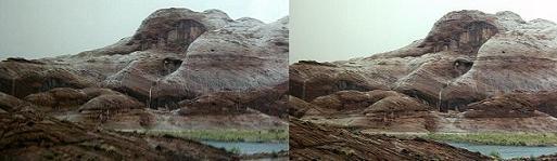
Same image as a stereo pair. |

Looking down south to the Golden Arches and beyond toward the mouth of Cottonwood Canyon, from the approach route (you can't get there directly from Cottonwood!) Note the houseboat moored far below. |
View south through the Golden Arches. The mouth of Cottonwood Canyon is barely visible through the right-hand opening. -- Unfortunately I don't have a good picture of the sunset glow on the arches from the other side. |
Note: A fellow Lake Powell explorer has another picture of this arch at his panoramic photos site. In his image the arches actually look golden!
Note: Later I discovered a Natural Arch and Bridge Society (NABS) website with pictures by Stan Jones of many arches in the Glen Canyon area, in particular what he calls Triple Arch. A friend who has Stan's map says it's labeled as such on that map. Frankly I hope the name "Golden Arches" is found to be more appropriate and desirable than the incorrect and uninspired "Triple Arch" even though the latter pre-dates my proposed name.
Note: Later I heard that the Golden Arches was for a time referred to as the "P T Bridge" (meaning unknown). Apparently there's an inscription on the wall nearby to this effect, but neither I nor the webmaster for NABS noticed it during our visits.
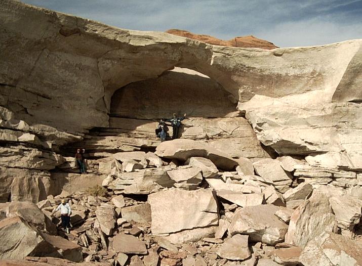
| 12. Peekaboo Arches | (map) | (up to summary) |
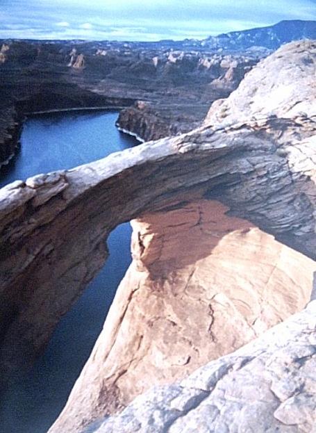
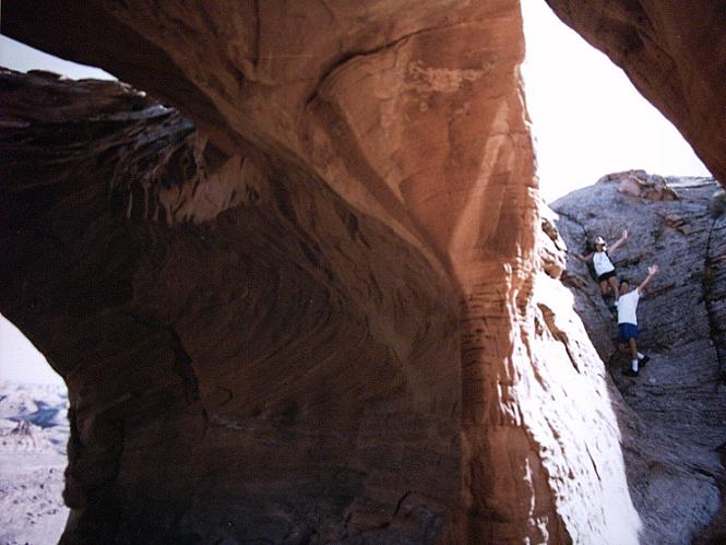
This fabulous, incredible set of "pothole arches" (Vreeland 7-11) resides more than seven hundred feet up a sheer cliff from the main channel of the San Juan River as it exits Piute Bay. It's merely labeled "rim arches" on some maps (but not others). It consists of a huge, approximately spherical chamber with a circular main opening looking out over Piute Bay; a circular hole in the ceiling; and a pair of "window and door" openings in the back wall -- a total of four holes! Behind the arches is a second, smaller pothole which is the access route down to the doorway.
Like the Golden Arches, discovering a way to Peekaboo was a route-finding challenge. Ultimately what I discovered was a most interesting ascent beginning in a small east finger in the northeast end of the "bend" of the next major oxbow (and lake-created island) downstream of Piute Bay. One climbs up through the Kayenta sandstone to a flat bench, then northeast through a gully chiseled in razor-sharp etched white limestone, and then proceeds in a long, ascending traverse up gullies and over a ridge of Navajo sandstone. The final approach to the arch is actually a bit downhill. The total travel time is about an hour and a half one way.
When I reached this feature for the first time, again I was surprised to find a register in an ammo can already present. The person who deposited the can had christened the arches "Peekaboo", and it is a perfect name! I'd just like to make it official.
I must admit having fallen in love with this remote hike and incredible arch complex. In particular, one September we moored in the oxbow finger, I took some people up to see the arches, and two of us huddled in the back of the cavity, barely out of the rain, during a massive thunderstorm just before sunset. We observed for ourselves what someone had written about in the logbook: During a storm the back pothole fills with a pond and water runs out through the "doorway" -- so again, is it an arch or a bridge? Later that evening we returned to the houseboat in time to watch a total lunar eclipse. And at about 3 am I awoke to bring two other people back up to the arches for sunrise!
I've crossed the rear arch over the doorway and window, but never had the courage to walk (or crawl) over the front bridge.
While driving a boat down on the lake there's a short stretch where all four openings of the arches are visible. It makes a fantastic stereo pair photograph with a telephoto lens.
Telephoto view up from the lake to the easily overlooked "rim arches". They are huge, but way above and small to the naked eye. All four openings are visible here, but the bright spot on the right inside wall is sunlight coming through the roof hole. 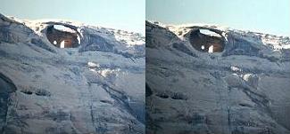
Same image as a stereo pair. |
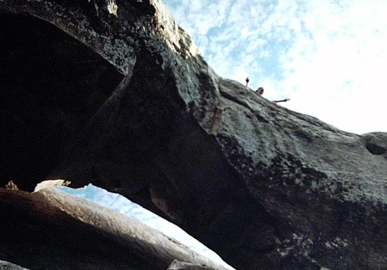
South downstream early in the morning, the San Juan River beyond the airy, scary front bridge of Peekaboo. |
Through the back doorway to the descent route into the rear pothole. The main and roof holes are barely visible on the left. |
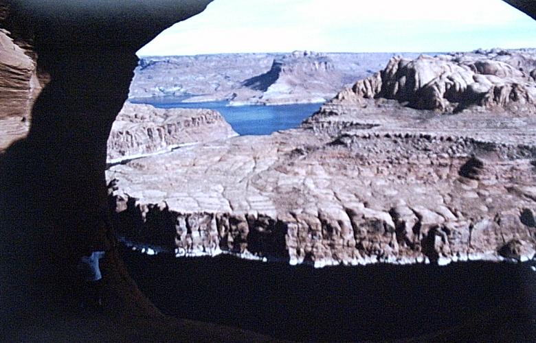
Southeast out the main opening down to the San Juan River, looking upstream to Piute Bay. |

The backside of Peekaboo, in more ways than one. |
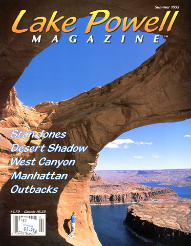
Later I received and added this picture from the Summer 1999 cover of Lake Powell Magazine ("subscribe now; call (800) 440-6507 or see www.lakepowellmag.com") It was probably taken with a wide angle lens. The person in the picture is in a very scary spot. |
Note: Later I discovered a Natural Arch and Bridge Society (NABS) website with pictures by Stan Jones of many arches in the Glen Canyon area, in particular what he calls Rim Arches. I've seen the name on a map, presumably copied from Stan's, as "rim arches" (not a proper name if I recall right), and also labeled simply "Arches" on another map in my possession. Note that the NABS site above states that the arches have three openings, not four, because, "Since the arch has a complex geometry, what you are calling a fourth opening is actually a different side or facet of the same arch." Anyway, frankly I hope the name "Peekaboo Arches" is found to be more appropriate and desirable than the mere "Rim Arches" even though the latter apparently pre-dates the former.
Furthermore, the NABS site led me to the discovery of the formally-named Peek-a-boo Canyon I'd previously missed in the GNIS due to the dashes, and to the apparently colloquially named "Peek-a-boo Bridges" under their Utah Gallery page. And I've been told by email: "There is also a Peek-a-Boo Arch in Capital Reef National Park, in Upper Muley Twist Canyon, Vreeland catalog number 9-22." Again this is apparently not a formal name.
Later I discovered that "Peek-A-Boo Arch" is an alternate name for Trail Arch in Utah.
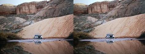
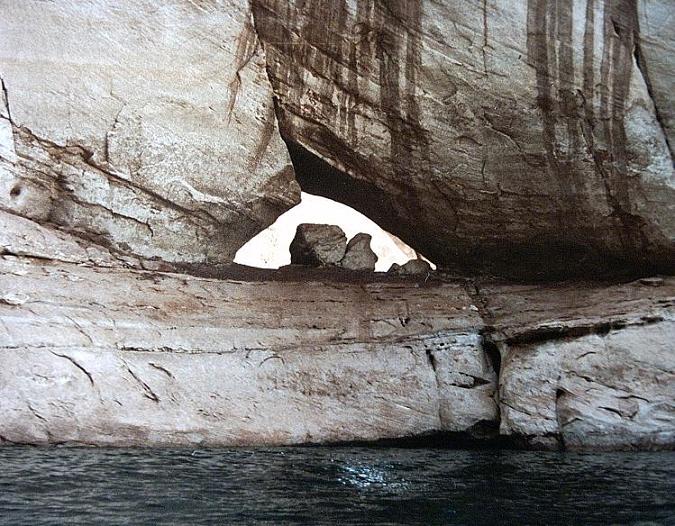
| 13. Twilight Arch | (map) | (up to summary) |
This sweet little (by GCNRA standards) arch (Vreeland 7-112) can be visited in varying states of submergence. I "discovered" it around 1990, moored a houseboat below it in 1991, and have snorkeled down 15' to look through it during wetter years. This is only one of two arches I know of on Lake Powell where it's possible at times to float a boat through the opening. (The other is the Alice J Arch.)
Since the arch is unnamed and is not mentioned on any maps, we naturally took to calling it the "Twilight Arch". I simply propose to formalize this attractive name. It's also appropriate since the arch abides low in a deep, narrow, dark canyon.
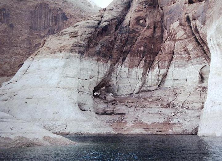
Downstream (southwest) to Twilight Arch when it's high above the lake. This is about the most open spot near the arch. |
Upstream (north) to the arch, showing the massive and unusual boulders at its base. |
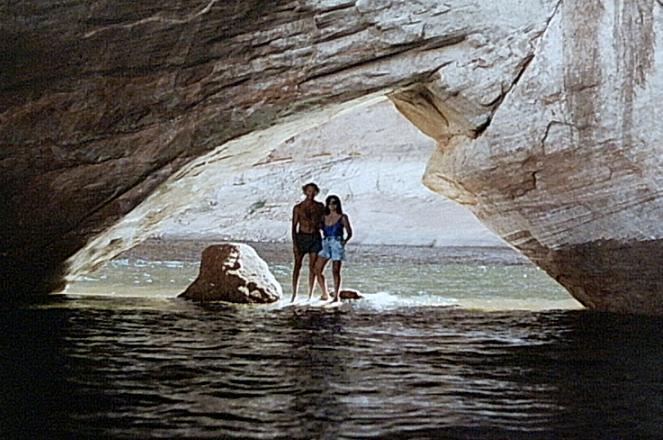
If you could walk on water you could sometimes stroll through this arch. Here the lake level is 3662.5'. |
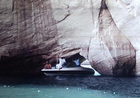
A ski boat maneuvers through the arch -- carefully -- at lake level 3666.4'. |
Note: A fellow Lake Powell explorer has another picture of this arch at his panoramic photos site. He thinks perhaps the arch should be called "Shark Arch" for its unusual shape. I agree that this name is fitting, but it never occurred to me in all my previous visits, and I still like the simple "Twilight Arch" better myself. But both names are worthy of consideration (shrug).
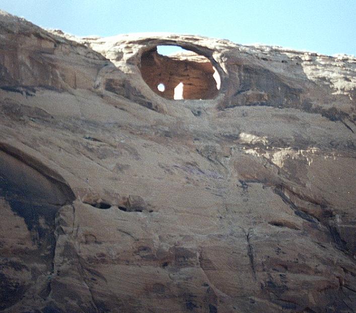
Note: Not far upstream of the Twilight Arch is the only exit we could ever find for reaching the impressive and well-known Eye Arch, which resides 400' above the lake on the narrow peninsula between Twilight Canyon and the main channel. It requires a nearly full pool to start the ascent, and a bit of semi-technical crack stemming, but a mere 20 minutes one way to reach the arch.
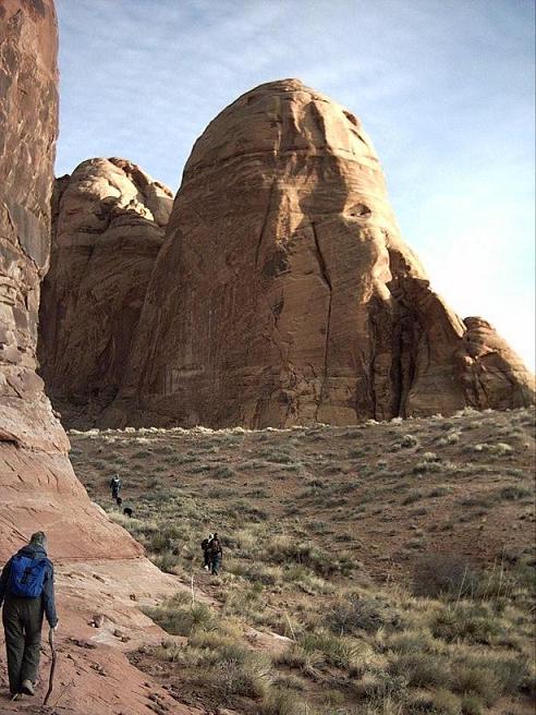
| 14. The Slope | (map) | (up to summary) |
Once upon a time a massive wrinkle in the Earth's crust -- an anticline -- became the Waterpocket Fold. This long, linear feature is the backbone of Capital Reef National Monument. At its southern end you find the Rincon, a 1500' tall "island" in the middle of a huge, prehistoric abandoned oxbow. Where the Colorado River cut through the oxbow it left behind high cliffs of Kayenta and Wingate sandstone above Chinle formation mudstones.
North and east of the Rincon is a huge tilted surface, the purplish top of the Kayenta, where the softer Navajo sandstone was mostly removed over the eons. Further north on the Fold the Navajo remains present and complicates the terrain, but The Slope emerges to the south in simple majesty. A feature of this scale and uniqueness merits the simple name I propose. A predecessor houseboat captain once told me, "It's just... The Slope."
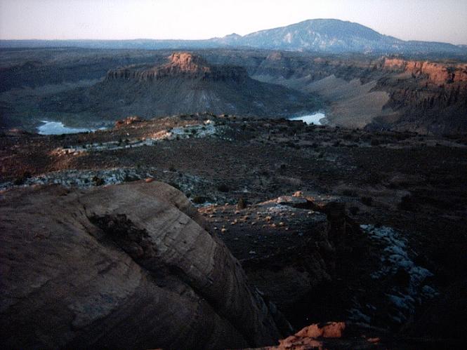
As one floats down the lake toward Iceberg Canyon, The Slope rises inconceivably vast -- and beckoning to explore on foot. One can walk up from the water to the summit of the ridge in about an hour and a half, thereby experiencing what we call simply, "The Slope Hike". Up close and personal on The Slope you see calcite crystals, deep gullies, hidden gardens, and of course water pockets (tenajas). Once on the flat crest, a short distance to the left is a fantastic view south over the cliffs to the Rincon, actually an elongated oval, but foreshortened from the north resembling nothing so much as a huge meteor crater with an enormous central peak.
The Slope is so monumental that in addition to giving it a proper name, I would like to label its two southernmost high points as well: Boulder in the Sky and Camera Butte. I also considered suggesting the name "The Cliff" for the unforgettable overlook point where the world ends at the south end of the Fold... Plus, at the base of The Slope rests an unnamed residual knob of Navajo sandstone that's a tough climb, quite monumental in its own right, and anywhere closer to civilization would bear a title -- but we've never thought of it as more than "the little knob on the base of The Slope."

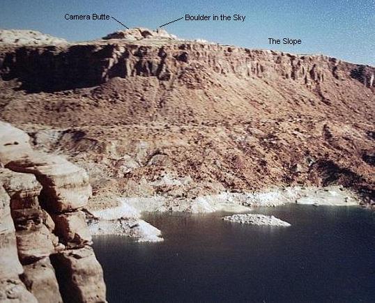
North across the lake to The Slope from the hillside below Aleson Arch, above Flying Eagle Cove. |
If you climb up and out of the downstream arm of the Rincon and look north across the lake, "The Cliff" is what you see. |
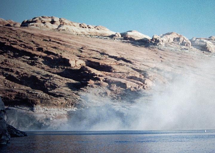
At 7 am one morning that was no early military jet we heard, it was a rockfall from the cliffs on the edge of The Slope! This view is out the mouth of Iceberg Canyon (note channel marker on the right) to the heights of the tilt. |

Looking up The Slope from the lake. You know the expression, "this picture doesn't do it justice"? ... |
View up the right (north/east) side of The Slope above the deep canyon upstream of the "little knob". |
When you hike up The Slope and look down it's not as impressive as looking up, but here's an idea of the view, including the "little knob" down by the water. |
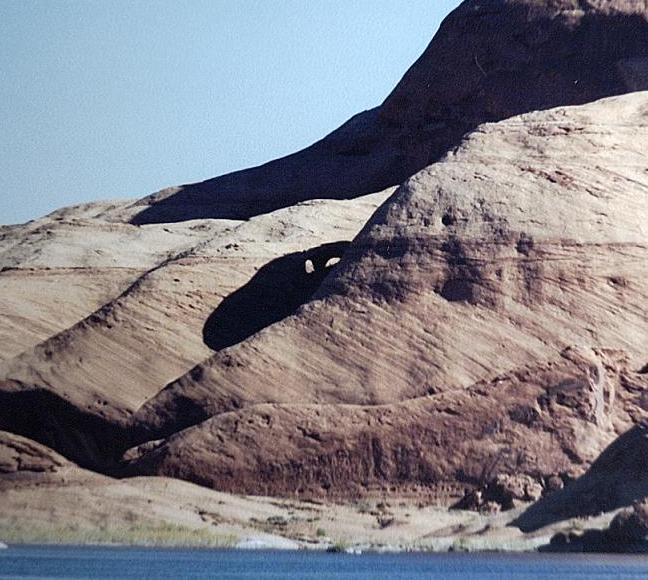
| 15. Boulder in the Sky | (map) | (up to summary) |
Some outcrops of Navajo sandstone still cling to portions of the south end of the Waterpocket Fold. As you proceed north from "The Cliff" overlooking the Rincon (whose summit also an intricate castle of Navajo), each successive "bump" is higher. The first two, Camera Butte and the "Boulder in the Sky", are especially interesting in their shapes, spectacular in their scenery, and tricky to summit the last hundred feet or so.
From the rounded, sandy crest of the Fold there's just one way to go higher toward the Boulder in the Sky. It's not obvious but it's delicious, a series of gullies and back and forth ramps that lead to a narrow ridgeline. Just when you're sure you won't be able to go higher, you find a way through to an enormous, solitary rock, the local high point, perched on top of the ridge. It's flat on top and big enough to share with perhaps ten of your friends. The view is incredible in all directions.
Frankly, for years we've referred to this point as the "Island in the Sky". However, someone beat us to it with the much better-known central district of Canyonlands National Park between the Green and Colorado Rivers. I assert that our summit on the Waterpocket Fold still deserves a designation. Therefore I propose "Boulder in the Sky" as a suitable alternative name, both befitting the feature and in deferential relation to the Island in the Sky mesa.
|
North across the lake to The Slope and the Boulder in the Sky from the hillside below Aleson Arch, above Flying Eagle Cove. |
Also if you climb up and out of the downstream arm of the Rincon and look north across the lake you can see the Boulder in the distance. (*) |
Up The Slope from the lake you can see the Boulder way in the distance if you know where to look. |

Higher and further north on the crest of the Waterpocket Fold looking south to the Boulder in the Sky, Camera Butte, and the Rincon. |
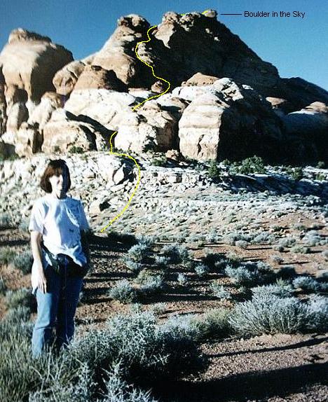
On the crest of the Waterpocket Fold (west of The Slope) looking north to the Boulder in the Sky, with the approximate final ascent route shown in yellow. (+) |
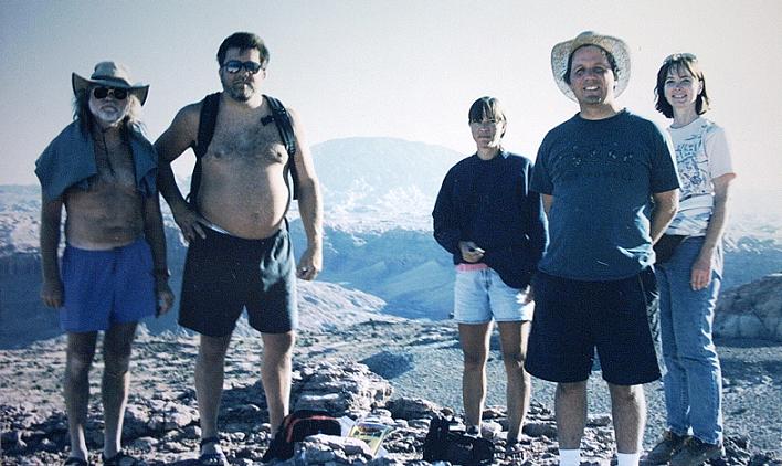
A motley crew standing atop the Boulder in the Sky. Behind them to the south is part of the Rincon, Navajo Mountain, and on the right the eastern part of Camera Butte. |
(*) Believe it or not there are people in this picture, on top
of "The Cliff".
I could barely see them... With binoculars!
(+) There's a person in this picture too.
I married her in June 2003.
She looks much less fuzzy in real life (grin).
| 16. Camera Butte | (map) | (up to summary) |
Once upon a time long ago I hiked up "Camera Butte" for sunrise. As described above, this is the highest residual bump of Navajo sandstone on the crest of the Waterpocket Fold south of the Boulder in the Sky.
Why "Camera Butte"? I built a small cairn on top of the hill and used it as a platform to take some pictures at sunrise. Later when a friend returned with me to the summit I pointed out the cairn, he admired the view, and then he dubbed the hill. Since then I've admired his creativity and I still think it's a great name.
On a later trip I backpacked up from the houseboat in the dark to spend a night alone on top of "Camera Butte". It was a fabulous, airy, eerie, lonely place to sleep.
|
Looking north to "The Cliff" and The Slope from northwest of the Rincon, Camera Butte dominates the top of the ridge. (The rocks at the upper left are higher but further away.) |
Higher and further north on the crest of the Waterpocket Fold, from the rocks on the upper left in the previous photo, looking south to the Boulder in the Sky, Camera Butte, and the Rincon. |
Sunrise south from Camera Butte across "The Cliff" to the Rincon and Navajo Mountain. |
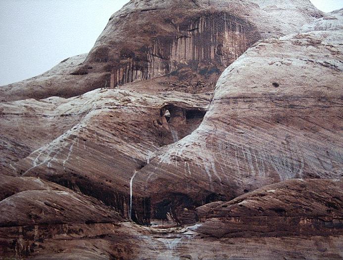
| 17. Chinle Cathedral | (map) | (up to summary) |
Walking up the left fork of Popcorn Canyon a short distance from the high water mark leads one through a breathtaking flat-floored chamber of fluted bluish-green walls. Higher above, the upper Chinle formation is a reddish mudstone surmounted by enormous cliffs of Kayenta and Wingate sandstone. Large chunks of petrified wood weather out of the blue volcanic mudstone to adorn the dry wash.
While the term "Cathedral" might seem generic, in the context of GCNRA it has special meaning. Witness the Cathedral in the Desert, as much as 150' underwater in Clear Creek Canyon off the Escalante River. And about 1.1 miles beyond the rear wall of Iceberg Canyon up the right fork, there's an absolutely incredible chamber surrounded by 700' high overhanging cliffs. We refer to it as "Dougs Cathedral" for the friend who "discovered" it many years ago as Lake Powell was first rising. But I'm not proposing that name here -- although Doug's getting along in years, he isn't dead yet (grin).
Note: When we first discovered the Chinle Cathedral we apparently nicknamed it "Temple Square". As it's anything but square, the proposed name seems better now.
|
Annoted photo of a USGS map showing Popcorn Canyon and the Chinle Cathedral. |
Looking down north-northeast from a 4670' high point to the Chinle Cathedral (mostly within the red ellipse), a closeup of part of a picture of Popcorn Canyon. |
A ground-level look northeast into the Chinle Cathedral. |
Another view northeast, a bit further upstream. -- Unfortunately these images fail to convey the three-dimensional quality and intensity of color in this roofless natural palace. |
Incidentally, you can keep hiking (and then scrambling over rough terrain) a long ways beyond the Chinle Cathedral. The upper Chinle formation created a deeply gullied, boulder-choked badland -- including a natural tunnel in the watercourse!
In conclusion, I thank the many crewmembers (71 different people in all) who have helped me explore and even name aspects of Lake Powell over the past 14 years and 29 boat trips.
Also my thanks and appreciation go to the members of the USGS BGN for considering my request, and to others who may take the time to comment on this proposal, for exploring GCNRA with me through this lengthy webpage. I hope you found it entertaining, and the proposed names worthy of your support.
The following table lists changes made to this webpage after it was submitted to the USGS BGN on January 28, 2004.
| Date | Changes made | |||||
|---|---|---|---|---|---|---|
| Jan 30, 2004 | In the the caption for the first photo for Camera Butte, the rocks on the left are higher but further away, not closer and lower. Also mentioned that the second picture was taken from that location. | |||||
| Jan 31, 2004 | Discovered a Natural Arch and Bridge Society (NABS) website with pictures by Stan Jones of many arches, including Peekaboo Arches and Golden Arches, with alternate names for them. Furthermore this site led to the discovery of the formally-named Peek-a-boo Canyon and the apparently colloquially named "Peek-a-boo Bridges". Added "notes" to each of the above detailed descriptions. | |||||
| Feb 2, 2004 | Oops! I seem to have swapped the coordinates for the nearby "Chinle Cathedral" and "Popcorn Beach; corrected that. | |||||
| Feb 2, 2004 | Added hyperlinks to Topozone maps to the summary table and to each section in detailed descriptions. Thanks Jenny for the great suggestion! | |||||
| Feb 4, 2004 | Thanks to help from the webmaster at NABS, added an explanation of "Vreeland Numbers" below the summary table, and indicated the V-number in detailed descriptions for four of the five arches which have those numbers. | |||||
| Feb 5, 2004 |
Prepared and added
stereo pair images where available -- for
Moriahs Arch,
Golden Arches, and
Peekaboo Arches.
Just for fun here are three more stereo pairs...
|
|||||
| Feb 5, 2004 | Discovered that Bell Tower Window might not be a true arch; added a discussion about this. | |||||
| Feb 5, 2004 | Discovered and described yet another historical name for the Golden Arches. | |||||
| Feb 5, 2004 | Discovered that I had the wrong spelling for "Mariah"! Added a note to the details on Moriahs Arch. | |||||
| Feb 10, 2004 | Improved the stereo pair for Peekaboo Arches, and while I was at it, added a couple more stereo pairs of other arches above in the change log. | |||||
| Feb 11, 2004 | Oops, under Flying Eagle Cove I said Aleson Arch was formerly known officially as "Flying Eagle Arch", but I see now on a Topozone map (based on a USGS map) that it's merely labeled "Natural Arch", so the previous name must not have been official. | |||||
| Feb 11, 2004 | Added to the Summary section a hyperlink for emailing comments to the BGN. | |||||
| Feb 12, 2004 | Embellished the text in the description of stereo pair images. | |||||
| Apr 17, 2004 | Received and added to Peekaboo Arches an image from the Summer 1999 cover of Lake Powell Magazine. | |||||
| Apr 18, 2004 | Added to stereo pair description section a pointer to some webpages about the View Magic viewer. | |||||
| Jun 9, 2004 | Added to end of Peekaboo Arches a mention that "Peek-A-Boo Arch" is an alternate name for Trail Arch in Utah. | |||||
| Jul 6, 2004 | Added to Peekaboo Arches a pointer to the Lake Powell Magazine site. | |||||
| May 13, 2005 | Fixed minor HTML typo. | |||||
| June 16, 2005 | Added column showing names approved, and copy of letter received. | |||||
| July 6, 2005 | Corrected (slightly) the coordinates for Bell Tower Window based on GPS reading (DOP = 0.9) standing on top of the window's west pillar on July 2, 2005. Also noted that the probable location shown in photos was incorrect. |
(converted from UTF-8 with some loss of chars)

						May 25, 2005

Dear Mr. Silverstein:

We are pleased to inform you that the U.S. Board on Geographic Names,
at its May 12, 2005 meeting, approved your proposal to make official the
names Bell Tower Window, Cha Bay, Flying Eagle Cove, Piute Bay, Popcorn
Canyon, The Slope, and Twilight Arch for seven geographic features
located within Glen Canyon National Recreation Area.  The new names will
be published in the Board's Decision List 2005, and have also been
entered into the Nations official geographic names repository, which is
available and searchable online at http://geonames.usgs.gov.  The
entries read as follows:

    Bell Tower Window; arch; in Glen Canyon National Recreation Area,
    1.7 km (1.1 mi) NE of the mouth of Ribbon Canyon; the name describes
    the resemblance between the feature and a window in a bell tower;
    San Juan County, Utah; Sec 31, T40S, R10E, Salt Lake Mer.; 371556N,
    1105101W; USGS map The Rincon 1:24,000.

    Cha Bay; bay; 3.2 km (2 mi) by 1.6 km (1 mi); in Glen Canyon
    National Recreation Area, at the mouth of Cha Canyon; named for
    nearby Cha Canyon; San Juan County, Utah; Secs 3-6, T42S, R10E and
    Secs 32-34,T41S, R10E, Salt Lake Mer.; 371000N, 1104900W; USGS map
    Wilson Creek 1:24,000.

    Flying Eagle Cove; bay; 0.5 km (0.3 mi) by 0.2 km (0.1 mi); in Glen
    Canyon National Recreation Area, 1.3 km (0.8 mi) S of the mouth of
    Iceberg Canyon; named for an arch that overlooks the bay that was
    once known as Flying Eagle Arch; San Juan County, Utah; Sec 1, T40S,
    R10E, Salt Lake Mer.; 371911N, 1104604W; USGS map The Rincon
    1:24,000.

    Piute Bay; bay; 4 km (2.5 mi) by 2.4 km (1.5 mi); in Glen Canyon
    National Recreation Area, at the mouth of Piute Canyon; named for
    nearby Piute Canyon; San Juan County, Utah; Secs 32-34&27-29, T41S,
    R11E, and Secs 4&5, T42S, R11E, Salt Lake Mer.; 371100N, 1104200W;
    USGS map Deep Canyon North 1:24,000.

    Popcorn Canyon; valley; 1.6 km (1 mi) long; in Glen Canyon National
    Recreation Area, heads at 374025N, 1102731W, trends E to join Glen
    Canyon; named for the calcite concretions found in the area; San
    Juan County, Utah; Secs 3,4,9&10, T36S, R13E, Salt Lake Mer.;
    374044N, 1102834W; USGS map Good Hope Bay 1:24,000.

    Slope, The; slope; in Glen Canyon National Recreation Area, at the S
    end of Waterpocket Fold, opposite the mouth of Iceberg Canyon;
    descriptive name; Kane County, Utah; Secs 2&3, T40S, R10E and Secs
    34&35, T39S, R10E, Salt Lake Mer.; 372027N, 1104650W; USGS map The
    Rincon 1:24,000.

    Twilight Arch; arch; in Glen Canyon National Recreation Area, within
    Twilight Canyon, 1.1 km (0.7 mi) N of its junction with Lake Powell,
    named in association with Twilight Canyon; Kane County, Utah; Sec
    24, T42S, R8E, Salt Lake Mer.; 370823N, 1105737W; USGS map Nasja
    Mesa 1:24,000; Not:  Shark Arch.

At the same meeting, the Board did not approve the remaining proposals
to make official the names Boulder in the Sky, Camera Butte, Chinle
Cathedral, Golden Arches, Not Annies Canyon, Not Cha Canyon, Peekaboo
Arches, Twin Edens Canyon, and Walking Rock Canyon.  These decisions
were made in agreement with the findings and recommendations of the Utah
Geographic Names Committee and the National Park Service, which
indicated the names were not needed.

					Sincerely yours,

					(signed) Roger L.  Payne

					Roger L. Payne
					Executive Secretary
					U.S. Board on Geographic Names